|
| Nanda Devi at Sunrise - golden glory |
Introduction
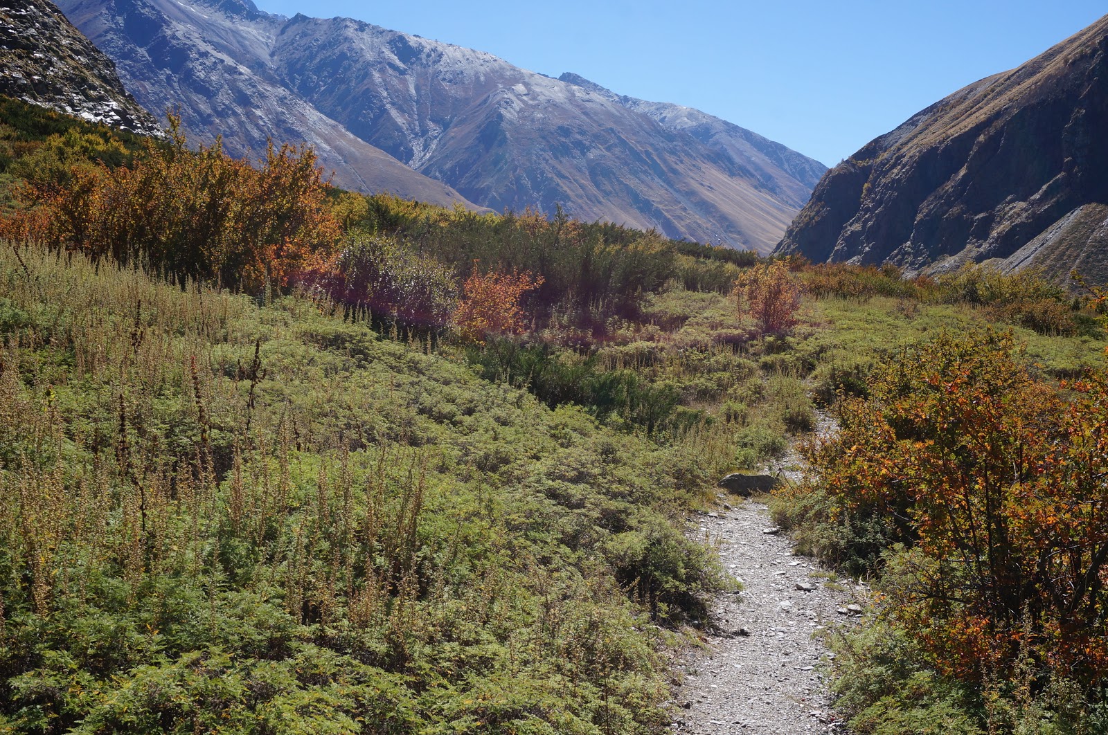
This nine day trek to the Milam glacier in Uttarakhand takes you
through the Johar valley – the ancient trade route between India and Tibet. In fact
trade thrived between the two countries until the indo-china war of 1961, after
which most of the villages in this region were abandoned by the locals and are
now in a derelict state.
This is a unique trek combining the mesmerizing beauty of Nanda Devi
and glimpse into the unpretentious culture of the local population of Kumaon.
Although it is possible to camp at most places, it would be a better choice to
stay in trekker’s huts or local home stays as it provides an opportunity to
sample local cuisine and observe the traditions.
The trek follows the river Gori Ganga throughout its course – all
the way upto its source in Milam glacier. Just a few kms. From Milam is Dung –
the last border village of Uttarakhand towards Tibet. Because of the
international border, a permit from ITBP (Indo-Tibetan Border Police) is
required before the commencement of the trek and trekkers have to record their
entry and exit at each check post.
This is a slightly longish trek – a 125 km in 9 days, making it more
demanding than many others in the region. The trail is well laid out for most
of the distance with rocky steps, but the avalanches on glaciers and landslides
every season often alter the routes in sections each season. And although the
highest altitude you will reach on this trek is just a little over 3500 metres,
there will be ascents and descents of more than 1000 metres on many days –
again raising the fitness bar. So you know that Johar valley is not for the
faint hearted!
For all its challenges, you will be amply rewarded with stunning
views of the highest and most beautiful mountain peak in India – Nanda Devi,
and other major peaks like Hardeol, Trishul, Raj Rambha….
And, not to mention the rich flora of this region. The trail is
strewn with plants of high medicinal and economic value. You will get to taste
a few that are included in local cuisine like Temur seeds, Jimbhu, Kala jeera,
Lai. The most interesting plant of this region is Keeda ghas (Tibetan name: Yarsagumba)
which is a mushroom named Cordyceps
sinensis grown over dead Hapilus
fabricus caterpillars which die due to snow fall. This is sold at an
exorbitant price of Rs. 12 lac / kg. in Tibet and China as an aphrodisiac. Men
in this region go to high altitude to collect this plant every year.
This trail is also home to Monal – the state bird of Uttarakhand, bharals
The Johar valley is also a rich mineral source – all through the
trek you will see mica scattered on the trail, and the bigger sheets are used
by the local inhabitants for the roof of their houses.
On this trek you will have it all – lush green valleys, snow-capped
mountains, meadows strewn with flowers, glaciers, small villages, the silver
river bed, gurgling water streams, starry skies – so clear, you will feel like
reaching out to the stars !!
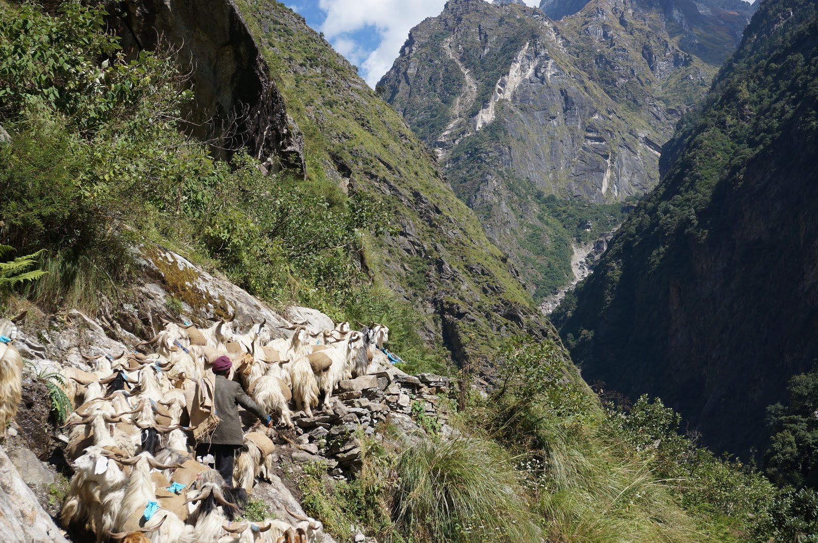
An interesting use of goats is unique to this region as a transport system on narrow trails where horses / mules cannot go, goods are transported on goat backs – in tiny sewn gunny bags containing 10-20 kg of weight. Usually the army of goats is 500 odd in number, and they are the ones most likely to cause a traffic jam in the mountains but it is a unique sight – Johar valley transport system.
 |
| Johar valley transport system |
Nanda Devi:
The highest Himalayan peak fully in India, this elusive summit is
rife with anecdotes – the locals worship Nanda devi as a goddess, and have her
temples in almost all villages – Martoli, Munsiyari, Milam. And true, goddess
she is! You will realize it when you see
her from the Nanda Devi East Base camp or while going to Milam from Burphu. A
lady with veil on her head, a head band and a nose ring – that is how she
appears and so protected that she is surrounded by an entire ring of peaks
forming the Nanda ghumti – the veil of Nanda devi. It was only in 1937 that
Bill Tilman could summit this peak and thereafter there have been few ascents
on this peak. In fact the inner sanctuary is closed from entering by tourists.
 |
| Nanda Devi - the goddess with a veil like a lady |
Best time for the trek:
The best time to do this trek is in May and September-October. In
May the route is opened by ITBP only after 15th May. June-July are
months of heavy rain and landslides, so not much of trekking happens.
Aug-September are reasonable with few bouts of rain but clear weather most of
the time. It is in May that the residents of higher villages start their upward
migration from Munsiyari. So trekkers can avail of the facility of home stay /
Dhaba. Although trekking continues in Johar valley well past October, the
villagers make their return migration in 1st week of October to
avoid colder climate.
The Trek Diary
This trek was undertaken from 27th Sept. to 5th October in 2015. This is a late post of the trek.
Access: The nearest roadhead for this trek is Munsiyari in Uttarakhand. One can reach Delhi by train or flight and then take an overnight train to Kathgodam or Haldwani from Delhi. From Haldwani and Kathgodam there are shared jeeps to Munisyari which take around 8 - 10 hours, and leave quite early in the morning - before 7 am. There is also a Shatabdi train in the day, but that requires and overnight stay at Haldwani to reach Munsiyari next day.
Day 1: Munsiyari (2990 mts) to
Bubbledhar (3300 mts.) via Nayansingh Top (3500 mts.)
Munsiyari to Chilamdhar by
Jeep – 15 km - 1 hour
Chilamdhar to Bubbledhar – trek 10.5 km – 5 hours
[Chilamdhar to Pungdeo – 2 hours trek, Pungdeo to Bubbledhar – 3
hours trek]
Today we reached the roadhead for the trek – Chilamdhar by a
jeep which took us out and down from Munsiyari.
From Chilamdhar, we took a steep descending trail for about 30 – 40 minutes, down to Gori Ganga river at around 1900 mts. A temporary bridge made of wooden planks is used to cross the river. From here on we ascended on a narrow muddy trail with rocks from the landslides.
 |
| The makeshift bridge to cross Gori Ganga river |
After ascending for about 15 minutes and crossing a stream, there was a large walnut tree and a tea shop just after it. This is the tea shop of Sai Polu – the village is further up, but did not go to the village and just had a brief stopover for tea / snacks.
 |
| The walnut tree and the stream which we crossed - looking back |
The earlier route to Milam via Lilam village has been washed away during the floods of June 2013. So one can go down to Lilam for entry at ITBP check post or directly head towards Pungdeo (locally pronounced as Pumteo).
From Sai Polu tea stall, it is mostly walking on a flat wide road, after crossing the river stream. The road is being constructed as a motorable road to Bogudiar.
 |
| The flat dirt road |
 |
| Village Lilam on the other side |
After about half an hour of walking on the flat road, we took a narrow trail amidst tall grass and shrubs. This trail gradually ascended while providing clear valley views to reach Pungdeo in half an hour.
 |
| Narrow trail amidst tall grass |
One might consider having lunch in Pungdeo as the trek from here to Bubbledhar is long and arduous. There are two dhabas / tea houses half an hour apart. The first one is one hour trek from Sai Polu tea stall – it is a traditional house with a couple of rooms and space for cattle. It offers some fantastic views of the surrounding mountains.
 |
| The dhaba at Pungdeo village |
 |
| View from the Dhaba at Pungdeo |
 |
| Some more stunning landscape from Dhaba at Pungdeo |
But we were not too hungry, so took the left trail and walked up for another 15-20 minutes, only to be rewarded by a resort like tea house which is situated next to a huge cave. Both me and my trekmate climbed up the cave, and were swept off our feet by the 360 degrees view of the valley and hills. And boy... did we mind the half an hour wait for the food at this place... Naah... The place has water source too from where we filled up our bottles to reach the Nayan Singh top.
 |
| The cave |
 |
| The Dhaba number 2 - half an hour from the earlier one |
 |
| How can I miss a photo opportunity against such a stunning backdrop |
 |
| The landscape just takes your breath away.... can't believe I was here for real |
From this tea house it is a continuous ascent till Nayan Singh Top –
gradual at places, steep at others. From this tea house there are three trails
– the right goes towards Lilam village, the right most which goes down to Bhui pato village and the left and upward going trail is towards Nayan
Singh top. The path from here follows the river course and the valley falls on
the right mostly. We went around the mountain and then zig zag up towards
the top. The trail does not have long zig zags but really short curves, so that
we reached Nayan Singh top in about an hour and a half from the tea house.
 |
| Path towards Nayan Singh top |
 |
| Steep steps leading upto Nayan Singh Top |
Nayan
Singh Top is the highest point of today’s trek at 3500 mts. And is named after
Nayan Singh a surveyor with British Survey of India in 1900 , who was fabled to
have accurately measured steps by which he would measure distance travelled.
This was a perfect place for some well-deserved rest as there were a lot of trees
and shade.
 |
| Grinning on reaching Nayan Singh Top - Arun with our guide Jagat |
 |
| People worship at the top - some bells, stones.... |
 |
| Bells and flags tied to pray for success of the expeditions |
From here we again descended to Bubbledhar. The trail is well marked
out, covered with pine trees but a little rocky.
Day 2 - Bubbledhar (3300 mt.)to
Nahardevi (3000 mt.) - 15 km - 6.5 hours
Today was going to be a slightly long day, so we started early. Right at the
start, there is a steep descent on a rocky path with mud, can become very
slushy and slippery if it rains even the previous night. The whole path is in shade of large trees, so it takes long for the water to evaporate and the path to dry.
 |
| Take the right trail going down |
About 40 minutes of trek on this descending trail takes you to another trekker’s hut which has the added advantage of some space available for camping –especially if you are a large group. The trail opens up a little here providing with excellent views of the mountains but as you trek down further, after about 10 minutes it is once again through a dense growth of trees.
 |
| The last of the three tea houses - has place for camping |
 |
| Open vistas after almost one hour |
It is
about half an hour’s downhill trek on this trail in the shade of thuner and
pine trees till Rargari bridge on Gori ganga river.
 |
| Raragari bridge |
This is at an
altitude of 2000 mts., so we had descended almost 1300 mts. In less
than 2 hours. This had taken a bit of toll on my knees, so be careful! One may opt to rest here or trek further for about an hour to reach a tea stall at
Siuni. We went up to the tea stall.
From here you cross the river using the hanging bridge (Raragari bridge) and go over
to the other side. The trail winds its way around the mountains as the river
flows on the right all the way up to Nahardevi.
 |
| The river flows to the right all through |
It is half an hour of uphill
trek on a fairly even trail after which there is a water stream and thereafter
the trail is land slide prone – full of loose rubble and rocks for the next
hour or so. On the way there is a tea stall at Siuni, which again, is extremely
prone to rock fall. We stopped here for some tea and maggi. Closer to Siuni
the river flows very close to the trail, almost as if it was beside us, so we rested for a while, had snacks
and even wet our feet in water. If the camp is at Bogudiar, there is no need to
hurry and one can indulge in playing in water.
 |
| The cool river water is tempting to wet the weary feet |
The trail after Siuni is rocky
with sand and mud all through and fairly wide mostly except for a few places
where we needed to walk in a single file. We had company and competition for right of way from large herds of goat and sheep in this stretch as they carry rations to Milam.
 |
| A common sight - sheep and goat carrying ration to Milam post |
 |
| Traffic jam caused by herds of sheep and goat |
The trail gradually winds its way up the mountain after Siuni to reach Bogudiar
(2450 mts.), so we did not feel the strain of an ascent. Most of the trek
after Rargari bridge was in wide landscape with a lot of sun with a few patches
in the shadow of the mountains or trees. However the last half an hour towards
Bogudiar suddenly becomes pleasant with lot of breeze from the river and lush
green bamboo on the side.
 |
| The shaded path towards Bogudiar |
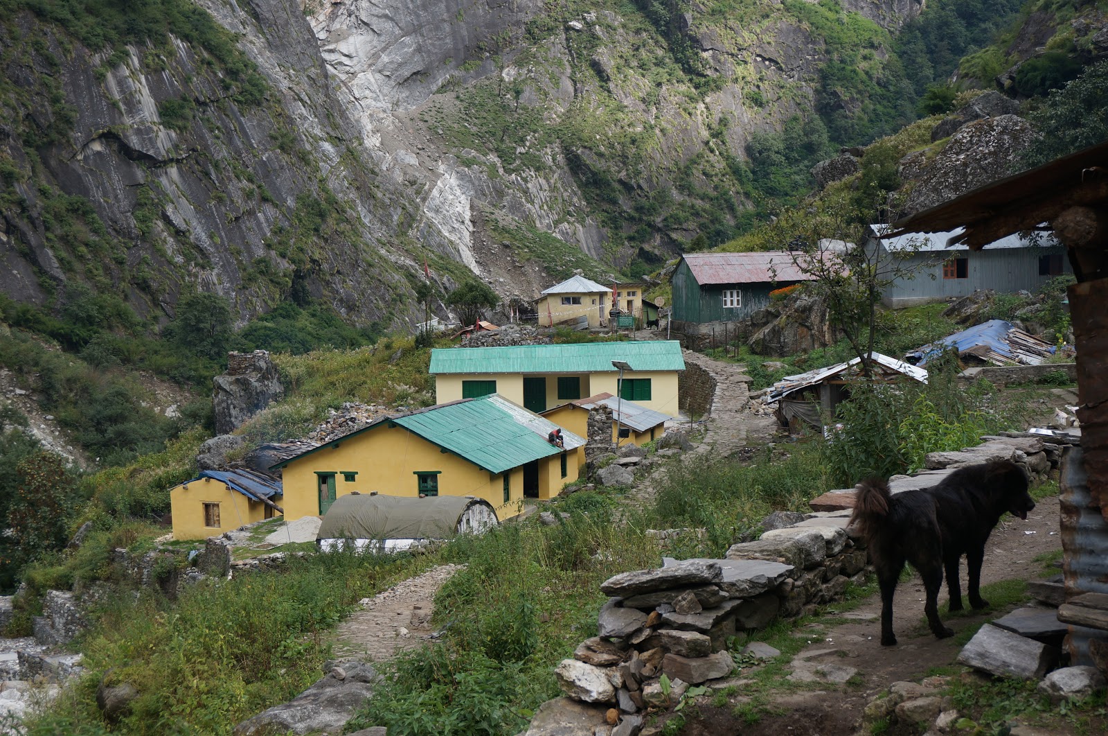
We reached Bogudiar by lunch time. It is required to make an
entry at the ITBP check post before you proceed for lunch.
 |
| The ITBP check post at Bogudiar |
There are 3 – 4
dhabas offering simple lunch. We rested for sometime after having lunch - actually took an afternoon nap.
 |
| The few Dhabas at Bogudiar - everybody takes a break - horses, men |
 |
| The path inside Bogudiar village - I kind of loved this place.. |
 |
| Bogudiar village - a few dhabas, 2-3 structures of ITBP...so little, yet so enchanting |
Our stop for the day, Nahardevi, was about 4-5 km from Bogudiar but it took 2 hours since it was quite arduous. Although the absolute altitude gain is 500
mts., it involved multiple ascents and descents winding around a couple of
mountains. Just after leaving Bogudiar the trail went all the way down to the
river where we crossed the river bed to go to the other side.
 |
| The little wooden bridge to cross the river |
Once again
we were following the river and gradually climbing up for about an hour after which
we sharply descended for around 500 mts. We had to make up for this
descent and ascend almost 1000 mts.to reach Nahardevi. This part of the trail
was the most scenic so far. We also had company of sheep enroute.
 |
| The sheep added another dimension to this picturesque landscape |
 |
| So rugged, yet so soothing himalayan landscape |
As we arrived at the Nahardevi campsite
we saw Peak Nagphuli in the distant front, Nahardevi mountains on its left and Soupano on the right. We caught last bit of lightAcross the top we saw a vast expanse of the river bed with sharp rock cut on the left. The trail for the next day was clearly visible from the top. There is only 1 dhaba here but ample space for camping and cooking with water source. We decided to camp, as the place inside the dhaba was dark and claustrophobic.
 |
| Nagphuli Peak in front, Nahardevi mountains on the left and Soupano on the right |
 |
| The river bed and rock cut behind our camp, next day's trail - but more importantly, sheer bliss |
 |
| Our camp - peering at the stars at night with river sound as a lullaby |
Day 3 - Nahardevi (3000 mt.) to
Martoli (3500 mts.)- 18.5 km - 9 hours
Today again we had a long distance to go, so we started early, especially since we needed to cross two glaciers with crevasses. Soon after the camp at Nahardevi, we crossed the river bed and walked on a trail made by blasting the rock.
 |
| Trail made by blasting the rock |
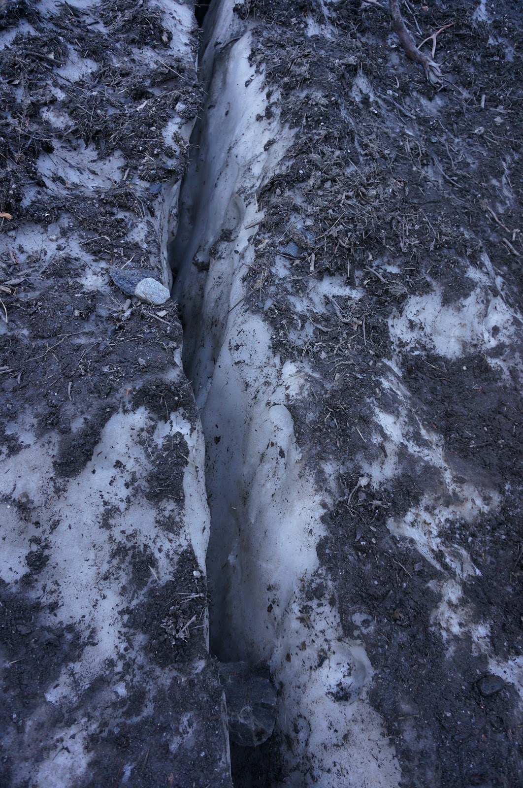
After 30 minutes of rolling trek (slight ups and downs but almost level) we crossed a mini glacier with narrow crevasses. Another 15 minutes after the glacier we crossed another glacier with huge crevasses. These glaciers are not permanent structures and change every year since they are formed due to heavy snow fall and separation of the ice deposits post winter.
 |
| The first mini glacier or avalanche ice that we had to cross |
 |
| The crevasse was long and deep but narrow enough to cross |
 |
| The crevasse in the second glacier required a little wooden plank to cross |
 |
| Makeshift bridge of wood to cross the crevasse |
 |
The crevasse with a water fall
These are not really glaciers in the strict sense of the word, but local guides refer to them as glaciers. We continued on this rolling trail for another 30 minutes and reached a waterfall. We had to cross underneath this water fall, so covered ourselves and the bag to avoid getting wet.
After this the trail slightly opens up and there was bright sunshine as the sun was on our right, just above the river. We ascended for almost 30 minutes till we reached a nice corner where we stopped for a brief rest and snacks. This is also a good place to stop if you are in a large group and are carrying packed breakfast.
|
 |
| Bright sunshine after a cold morning |
 |
| Looking back from our rest stop |
 |
| The trail ahead after the rest |
An earlier bridge on the
river was broken during the 2013 floods, so we had to trek down to the
river bed which took us almost 2 hours from this point.
 |
| The bridge on the river washed away in the flood |
 |
| Previous landslides washed away parts of the trail |
 |
| We had to cross boulders like this after getting all the way down to the river |
 |
| Arun and Jagat crossing the boulders - this was for almost 1 hour |
After crossing the riverbed, the trek is a steep uphill climb to Laspa, but it did not take more than 15 – 20 minutes. And after Laspa we walked in the meadows all the way till Rilkot, on a rolling trail. It took almost 6 hours to reach Rilkot from Nahardevi as the distance is around 12 km. We had lunch and rest at Rilkot. It is also possible to camp here.
Rilkot is an excellent campsite – picturesque location, ample camping ground, availability of satellite phones at the ITBP check post, a river flowing nearby, and abundant water. If you camp here, you could trek to Martoli or Burphu the next day.
 |
| Trail enroute Rilkot |
 |
| Rilkot - no words to describe the serenity of this place |
 |
| Taking in the beauty as I rest at noon after lunch |
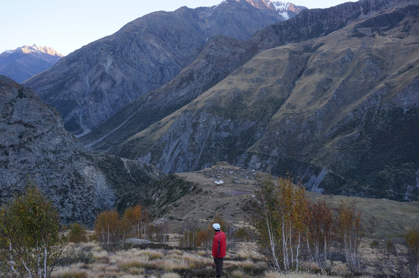
After a hearty lunch and well deserved rest at Rilkot, it is another 7 km of trek till Martoli. From Rilkot we once again trekked down to the river for almost half an hour on a steep downhill trail and then gradually ascended till the road head to Martoli. The trail is mostly made up of loose rocks and sand and the last bit before the road is a little steep. Just 5 minutes from the road head, we saw old Martoli on our right side, which the residents had fled following a thunderstorm. Out of curiosity I walked up to the village to see empty houses without roofs.
 |
| Looking back at Rilkot from the road head |
 |
| Empty houses of Old Martoli |
We continued walking on a flat motorable road
for about 2 km. after which we came across a sign board showing an upward trail to Martoli whereas the straight road leads to Burphu. One needs to take the upward trail to Martoli which is a proper pathway made of stones through the meadows all the way upto the village. It is not necessary to go to Martoli if you are heading to Milam, but I had read so much about Nayan Singh Rawat and his brother who were from Martoli and were instrumental to discovery and conquest of many Himalayan peaks in India by the British survey of India during early 20th century, including Nanda Devi herself. For me it was a pilgrimage to the village of Nayan Singh Rawat.
 |
| This is where the trail divides - upper one to Martoli and lower to Burphu |
 |
| This board is seen once you take the upper trail |
 |
| Route to Martoli - big peaks seen in the horizon |
From Martoli peaks like Nanda Devi, Nanda Devi East, Nandakot, Hardeol, Trishul can be seen. There is also a temple of Nanda Devi on a hill called Jhandadhar.
Martoli looks like a ghost village with some 40 – 50 houses and a village Panchayat, but mostly unoccupied. The roofs are made with Mica sheets which are abundantly available in the region. There were inhabitants in just 2 – 3 houses which double up as home-stay for trekkers. We stayed with an old lady who cooked excellent millet roti (called Madhuve ki roti in local language) with a chutney made with hemp leaves and some yellow-orange coloured tangy berries called 'Turruchuk' in local language.
 |
| A village home in Martoli where we stayed - notice the roof made with mica |
 |
| A room in a traditional home in Martoli - Arun slept on sheep skin, but I preferred the sleeping bag! |
 |
Martoli Village with Jhandadhar Peak in background
 |
| Sunset over Trishul |
|
Day 4 – Martoli (3400 mt.)to Milam
(3500 mt.) - 15 km - 6.5 hours + trek to Jhandadhar and back ~ 5
km
Today we would be trekking to the final destination of our trek i.e.
Milam from where we would go to Milam glacier. The trek is about 15 km. It
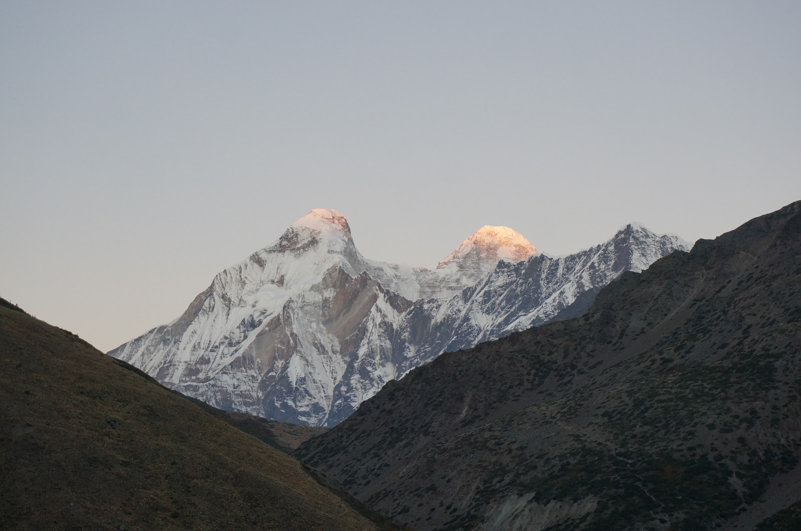
is highly recommended to try and trek as far as possible towards Jhandadhar
peak in the morning to get magnificent views of sunrise on the Nanda Devi. It takes about 3-4 hours to get to the peak, which meant that we start at night, but we were headed to Milam the same day, so we decided to start at 5 am and trek till the midpoint to Jhandadhar peak from where we would get unhindered views of Nanda Devi and would be just in time to catch the first rays of sun on the lovely twin
peaks of Nanda devi and also see Trishul on the other side. However, in the retrospect I think it would have been better to stay for a day at Martoli - enjoy the ghost village and also trek to Jhandadhar Peak.
The first 15-20
minutes of the trek was straight forward – on a paved pathway and took us to the Nanda Devi temple. This temple is highly reverred, not just by the
locals, but also by mountaineers. Many expedition teams tie a metal bell
engraved with the name of their expedition / team in the temple to seek
blessings of Ma Nanda Devi for the success of the expedition. An annual
festival is held in this temple where people from surrounding villages gather
to perform religious rituals. Surprisingly the practice of animal sacrifice has
been discontinued in this particular temple. We went to the temple after the sunrise, so that we could see it properly.
 |
| Nanda Devi temple with Nanda Devi in the background - after sunrise |
 |
| The bells tied for success of expeditions - we could read names of mountaineers and expeditions |
 |
| The bell for lesser mortals like us - I was satisfied to ring it |
 |
| Nanda Devi at dawn - when we started trekking the moon shone brightly over the beautiful peak |
We reached the point from where we would get unhindered views of Nanda Devi in 1 hour from our homestay. As we sat on the grass enjoying the crisp mountain air, the sky around was still blue, the moon shining on the peak of Nandadevi and Trishul – making them look like silver. And then the drama unfolded – a ray of sun just touched the tip of Nanda devi peak colouring it in pink-orange hue, the colour gradually spread over the entire peak and changed from pink-orange to a golden yellow. In front of my eyes was a shining mountain of gold. And gradually the color lightened and in another 20 minutes the majestic peaks of Nanda devi and Nanda devi east stood in front of us in all their splendor. I was speechless....I am glad I and Arun made the effort to start the trek early and could witness this grandeur.
 |
| Nanda Devi at dawn - the colours are yet to begin |
 |
| Trishul at dawn - it is on the opposite side of Nanda Devi, so does not become orange-golden... |
 |
| The first rays of sun on twin peaks of Nanda Devi and Nanda Devi East |
 |
| The colour grows on the peak and on you |
 |
| The gold is spreading |
 |
| When the sun touches tips of Trishul |
 |
| Finally in full glory... |
 |
| Coming back to the village after seeing the sunrise - the landscape is surreal |
 |
| Longstaff col - discovered in 1901 while trying to reach Nanda Devi |
 |
| Back to Martoli village - our humble dwelling |
We started the trek after breakfast from our rations as the old lady of the house didn't have anything left. The trek from Martoli began with a steep descent of almost 1000 metres to the river that comes from Nasanapatti. We had to cross the river using a makeshift bridge of bamboo. There used to a permanent metal bridge but it got washed away in the floods of 2013.
 |
| The makeshift bridge to cross the river |
Soon after crossing the river we started ascending 800 metres till the road head leading to Burphu. But surprisingly it did not take long – just 20 odd minutes. From here on it is a flat to slightly ascending trek of 13 km on a motorable road to Milam village via Burphu and Bilju. However vehicles regularly ply between Milam and Burphu for ferrying workers of GREF and ITBP road projects. Since we did not have a proper breakfast in the morning, we stopped at the tea house just near the Burphu bridge as our guide told us that we will not find food anywhere until Milam. Since there was no trail from Burphu to Milam, we decided to hitchhike in the GREF truck, and it was an experience of a lifetime. The ride was extremely bumpy, we had to hold the rails of the truck hard or a rope tied to it. We were bathed in mud and our spines ached by the time we arrived in Milam.
 |
| Burphu bridge seen from the tea stall |
 |
| Notice the little structures - that is the tea house |
The trek from Martoli to Milam takes about 5 hours, so one can have
lunch on reaching Milam. Milam is the strictest of the ITBP checkposts on this
trek, as it is the border. They checked our camera and warned about areas
that we were not supposed to photograph. One has to comply with the instructions as
this is a sensitive Indo-China border. In fact foreigners are not allowed to
take pictures and their cameras are deposited at the check post and handed over
to them only on return.
Milam used to be an important border village on the silk route to Tibet from India. It was a thriving village of 500 – 600 families, but urbanization and lack of opportunity in trade with Tibet after the Indo-China war of 1961 has resulted in the town becoming deserted (becoming a ghost town?) with hardly 5 – 10 houses now which also double up as guest houses for trekkers / tourists in the months of May through October. We also stayed in one such house.
 |
| Most houses have such small doors through which you have to sit and crawl inside |
 |
| The simple room coated with mud where we slept |
There is a Nanda Devi temple in Milam which is maintained by the
ITBP and has been reconstructed after it was damaged during the flood of 2013.
The sky is also clearer than other campsites due to altitude and open terrain,
hence we had the opportunity to watch the night sky studded with stars. I and Arun chatted away late into the night under the stars....
Day 5 – Milam (3500 mt.)to Milam
Glacier and Back then to Bilju (3400 mt.) -
20 km - 5.5 hours for the glacier
visit (14 km) and then 1.5 hours to reach Bilju (6 km)
Today was an eventful day - trekking upto Milam glacier and then going down towards Bilju village from where we would be able to see Nanda Devi at really close quarters. So the trek diary is divided into two parts:
- Milam to Milam glacier and back
- Milam to Bilju village
Milam to Milam glacier and back:
One needs to start early so that the glacier can
be visited before the sunlight becomes strong. It is 14 km to and fro on a difficult
terrain, so would easily take 5 – 6 hours at a moderate speed.
We started at 5:30 towards Milam glacier. At the start we passed through the ruins of Milam village on a paved trail and continued walking on a rocky path surrounded by meadows, full of edible berries, herbs etc. on both sides. After a brief 5 minute walk on a straight path, there was a fork on the road – we took the right and kept walking through the village. The village path was well made with big rocks made into a sort of road, and after the village we walked on moraines with rounded stones for about 3 ½ km to reach a view point from where the peaks of Hardeol and Trishul can be seen. It took us almost one hour to reach this view point at 3500 mt.
As the sun
came out, it fell on peak of Hardeol, colouring it golden. Trishul was on the
right side, so slanting sun rays fell on it.
 |
| Sunrays falling on Hardeol peak, colouring it golden |
 |
| After the sunrise - Hardeol in the centre, Trishul on the right and Rishi Pahar on the left |
After breifly stopping here for
pictures and having our packed breakfast, we proceeded ahead towards the glacier. There were
bushes of tangy berries called Turruchuk which are made into a tasty chutney
along with hemp leaves. There were also bushes of Shepla – another yellow
coloured sweetish berry, which I had also seen near the Nanda devi temple.
 |
| Turruchuk berry bushes on both sides of the trail |
It is believed by the locals that the glacier was originally 19 km
long and reached upto this view point at 3500 mts.
The glacier is further 3.5
km away from this view point and it took us about 1.5 hour to reach there from the view point.
As we walked on moraines and mud further, we slowly went down all the way to the
Gori ganga river bed, in fact walked next to the river, so close – I could touch
it.
 |
| We descended and walked next to the river - notice my shadow in the water |
The original path to the glacier had been washed away in 2013, so now the only approach was through the river bed for
about 1 km, and then ascending towards the snout as we reached closer. The
last
2 km of the trail to the glacier snout was all moraine and it is believed to be
on the glacier itself.
 |
| The barren flat landscape before descending to the river |
At places we could see huge blocks of ice on sides, separated from the main glacier. Since
this is an old glacier, it is covered by rocks, sand and mud and one cannot
really see the ice… but the very fact that you are walking on a glacier feels
creepy…The last ½ km was quite tough on scree and I had a tough time slipping and climbing.
We reached the point from where snout of the glacier was visible at 8:15 am - almost 3 hours after leaving our camp. We took pictures and sat for a while. We could see large blocks of ice separated from the snout. The glacier snout had changed direction, hence the river was now coming out from the left side of the snout. This glacier is different from others in the way that one can hardly see any ice due to deposition of debris,mud,moraine on glacial ice. If one has time and facility to camp, one can also go around and go to the other side of the glacier and further to Suraj Kund, but specialized equipment might be required for it.
 |
| My trekmate Arun at the edge of the glacier - Milam glacier snout in the background - notice the river coming out from the left of the snout |
 |
| The team at the final destination - me, Arun and Jagat our guide from Munsiyari |
 |
| Nibbling at an apple while descending on scree - this was difficult going up |
After descending on scree we rested for a while near the river, nibbling on the apples Jagat had brought for us.
We reached the guest house at 11 am – quite
exhausted. Due to early morning or cold winds – not
sure of the reason but I had a terrible headache on coming back. So I had
breakfast and slept after takign medicine for half an hour. As everyday we were
once again treated to a hearty breakfast of soft fluffy rotis with jeera aalooo
flavoured with locally grown shahjeera and Jimbhu leaves. Thankfully I felt better after the
sleep.
 |
| The team - two of us with our guide and porter |
Milam to Bilju village:
We had already trekked almost 14 km, so didn't want to trek long distance till Martoli. We decided to stay at a village closer - Pachu, Bilju or Ghanghar. Jagat – the guide, had inquired with some people about possibility of stay at Bilju. We were told that by now most people from the higher villlages were migrating back to Munsiyari. So there was no one in Pachu and there were 1-2 families in Ghanghar, but to our goodluck there was a family in Bilju who was migrating to Munsiyari the next day and was willing to host us.
We started our journey to Bilju at 2:30
pm. After
collecting the documents from ITBP check post we started walking down towards
Bilju. The trek to Bilju is 6 km from Milam and is mostly downhill on a motorable road. Soon after leaving Milam we came across Kolganga river – coming from Tibet.
 |
| The bridge on KolGanga river |
 |
| KolGanga river coming from Tibet |
Rest of the route was also lovely with views of Hardeol, Trishul, Jhandadhar and front view of the majestic Nanda devi as we reached closer to Bilju.
 |
| Hardeol, Trishul and Jhandadhar peaks |
 |
| Moraine mountains - almost a flat walk out of Milam |
 |
| Mountains, moraine and a path leading to nowhere... I want to be lost here |
 |
| Magical terrain - as if from a different planet |
|
We also saw another river joining Gori ganga around the village Bilju. On its opposite banks are villages Ghanghar and Pachu which are used as a base to go to Nanda Devi East Base camp.
 |
| Another river meeting near Gori Ganga just before Bilju - Nanda Devi east base camp is across the river |
The highlight of the day was Bilju village.
We had selected it for the ease of reaching after a longish trek to the glacier
and back but it turned out to be the best place of stay so far into the trek.
Bilju is a quaint little village of just 15 houses, well laid out with some
land in each house to cultivate vegetables. The people and their hospitality
are remarkable. We stayed with a family who hosted us inspite of it being their
last day in the village and treated us to authentic local cuisine – Sattu with
salt tea, millet roti (Madua) with mixed dal and home grown cabbage curry. The
house was a neat one with mud lined walls and floor and a small entrance
through which one has to stoop to enter.
In fact most houses in other villages also had similar small entrances –
probably to prevent cold wind from coming into the house. The people do a
special puja / ritual and pack their houses before their annual migration to
Munsiyari in October. They then tend to their other agriculture / business in
Munsiyari for the next 6-8 months till May – when they come back to their hill
abodes.
 |
| Bilju village seen from a hill top shrine near it |
 |
| Our five star accomodation in Bilju - great food, lots of love |
Day 6 – Bilju (3400 mts.) to
Rilkot (3130 mts.) – 17 km trek – 4.25 hours + trek to view point to see Nanda
devi about 4 km
This day was once again an early start. We left
the guest house at 5:15 am to see the first rays of sun falling on Nanda devi twin peaks.
Each early morning so far has been better than the previous one. Today was by
far the best. Her highness Nanda devi revealing her majestic beauty in its
golden splendour. The snow clad peaks turn from dull white to orange to golden
and then shining white again. As if the Sun comes out to adorn the goddess Nanda Devi with golden ornaments! Nanda devi is truly the queen of peaks in India.
 |
| Nanda Devi and Nanda Devi East peaks before sunrise |
 |
| The first rays falling on the tip of both peaks |
 |
| The changing colours to pink-orange |
 |
| The golden taking over the pink |
 |
| Both peaks resplendent in gold |
 |
| The peaks shine in white as the sun rises fully |
Thereafter we returned back to Bilju by a different route where we crossed the village houses and realized what a well planned village it was. Each house with a designated living room, kitchen, space for cattle, some kind of farming. There were also public utility buildings like Panchayat house.
 |
| The perfectly planned village with neatly lined houses and alleys |
 |
| A typical house with place for cattle, farming, storage and living |
We came back to our home stay just to collect the bags and say good byes to the family we stayed with. Their goats had already been sent off, the house was neatly packed with some ration left for emergency, and now it was time for the family members also to leave. They were going to reach Munsiyari in 2 days flat, and we had planned to reach in 4 days!
 |
| The family that hosted us - bidding good-bye to them and the village as we all leave |
We started the return journey at 7:15 am.
Having trekked for 5 days now, we were much fitter and reached Burphu bridge ,
about 6 km, in about 1 hour 15 minutes. The trail was all through on a
motorable road and downhill.
 |
| The magical landscape soon after leaving Bilju village |
We took a breakfast break at the tea stall near the Burphu bridge and resumed our trek towards Martoli after 40 minutes . Here we met a mother-daughter duo from Austria and wished them good luck. The trail was still the same for about 3-4 km and there are a few streams almost every half an hour. After this we reached a downward trail towards the river. This area is Laspa. We crossed the bridge and went up on the other side towards road head.
We had an interesting experience . The rocks were being blasted to make a road by GREF. We waited on the other side and watched the entire process excited like little kids since it was a first experience for both me and Arun.
 |
| The place where the blasting took place. I was so engrossed that forgot to make a video |
Then we continued walking on the road for 4 more km till finally Rilkot can be seen. In between we saw Tola villge on our left – just next to the river. We descended to Rilkot by a muddy trail. Rilkot is a beautiful camp because of the vast river bed interwoven with multiple streams of the river.
 |
| Rilkot - river at sunset |
An interesting thing has happened in these 4 days. Our
capacity of walking has increased significantly. Today we reached Rilkot in
just 4 hours – a distance of 17-18 kms. We had reached by lunch, so had ample time. After lunch we went down to the river and hung around till sunset. Yesterday also we joked that we were
not tired since we had not walked much – and we immediately recollected that we
had walked for 20 kms. !
That is why we hope to walk 20 km + over the
next two days and reach Munsiyari a day earlier than our original plan.
Today we met a major from Indian army going
for a leisurley trek towards Milam with his beautiful wife. He had summited
seven major peaks in the world including Everest!! it was truly a privilege to
meet him. And what a handsome guy he was... how I wish his wife was not accompanying him :)
We stayed at trekker’s hut in Rilkot and enjoyed the evening.
Day 7 – 3rd
October 2015
Rilkot to Bogudiar 18 km – 5 ½ hours
Today we had decided to start early so that we could cover more distance, but we ended up starting at 8:15 am from Rilkot since Arun lost his wallet and we
spent almost 1 hour in searching for it and subsequently reporting it at the
ITBP check post in the hope that someone at least returns the wallet – sans the
money. Today's trail was mostly rocky with some very sandy patches. One of the glaciers near Nahardevi had broken off, so we had to go down to the river bed and then go up again to reach Nahardevi.
 |
| The broken pieces of the glacier near the river bed |
 |
| Many large chunks of ice had fallen off in the river the previous day |
We reached Nahar devi at 12:30 and stopped briefly for Maggi and tea. Now we were crossing familiar trail, so were walking at a hurried pace, as there was not much new to see. We
finally reached Bogudiar at 2:30 where we had lunch and met an interesting
elderly couple from Germany who trekked to Milam every year! We had
originally planned to go to Siuni, but it started raining in Bogudiar, so we
stayed there in the forest guest house – a luxurious accommodation in the hills
with a bed and thick warm blankets !! We had lots of candle light gossip and candle light dinner!
Day 8 – 4th October 2015
Bogudiar to Bubbledhar – 11 km - 5 hours
We started from Bogudiar leisurely as it was not a very long trek today. If we started early, we could reach Munsiyari today itself and would have 2 spare days. Instead we decided to take it slow and enjoy the mountains. We chatted with locals on our way. A family was carrying a new born calf down to Munsiyari with them. Arun enjoyed petting the calf.... We reached Bubbledhar around lunch and lazed around. Explored the vegetable garden of the family we stayed with, played with sheep and rested.
 |
| One day old calf with its mother and caretakers |
 |
| The landscape from Pungdeo dhaba |
 |
| The dhaba at Pungdeo where we had lunch - looked even more enchanting while returning |
Day 9 – 5th October 2015
Bubbledhar to Chilamdhar and Chilamdhar to Munsiyari
We bid good-bye to the family that ran the tea house at Bubbledhar after breakfast of Roti and Lai ki sabji. Today was an arduous trek - once again climbing up to Nayan Singh top and descending it, but we were at the peak of our fitness and it was the last day of the trek - so nothing seemed much. The only boring part of the trek was the last 2 hours from Sai Polu to Chilamdhar on a road that was being made motorable. We reached Munsiyari by evening.
We were happy to have completed a 125 km trek in 9 days, the views of Nanda Devi still lingering in our minds...